Sunday, December 30, 2012

On To Joshi Math


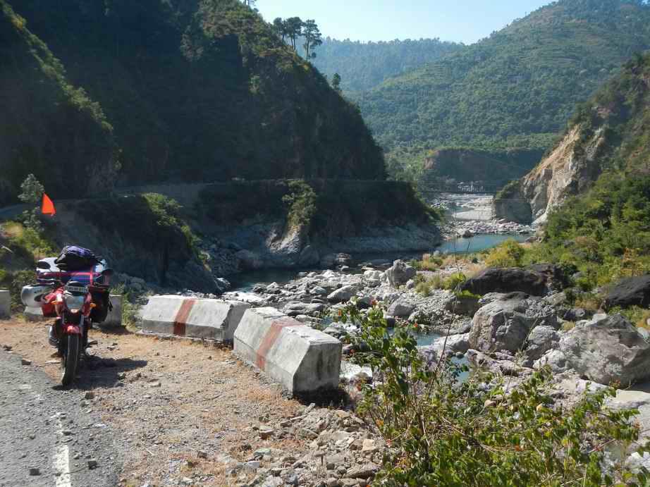
Unlike the way to Munsyari which generally moves parallel to the valleys (north and south), the way to Joshi Math goes east and through the mountains. Since most of the goods and people move into and out of the mountains using the north south routes, the cross mountain roads are rarely used. For much of the day I only passed two vehicles. Even though the distance is not too far much of the route was at 15-20 KPH (10-13 MPH). What the route lacked in being a road it certainly made up for in scenery and vertical relief.


This is a National Highway by the way.

A friend sent me the following link that gives a video view of the situations often encountered buts its rather sensationalized. The video shows only every day run of the mill stuff. Waterfalls, for instance, over the road., occur regularly often nearly every inside curve contains a waterfall. The bad ones are where the force of the water has washed away the road material and you are left with only large rocks for a surface. This is bad enough to go across but a foot of rushing water makes it even more interesting.


On the way up the valley along the river flowing from Badrinath and Joshi Math I looked over the edge and saw an interesting construction project. A true Bridge to Nowhere. It is hard to see from the photo, but I am looking straight down nearly 1,000’ at the bottom is a large piece of construction equipment excavating the other side which is also as vertical. Since there is no way it could be for a road (or you never know) I can only assume its for some hydroelectric project.


Joshi Math sits above the confluence of two rivers at about 7,000’ with views up both valleys.


The following day I am heading higher into the midst of the big peaks, to Badrinath.

Badrinath is around 9,000’ and is a major pilgrimage destination during the summer months for its important  temple. Mid October is when the snows start so things are about to shut down for the winter. Since Badrinath is situated in the big mountains, the road along the valley is on even stepper ground.


Moonset over one of the side valleys coming into the main river.


In many places the road is actually like a half tunnel cut into the rock face.


As the road ascended, some of the glaciers started to come down near the road.


Upon arrival, the first thing I do (well after a delicious lunch at a place directly in front of the temple) is to ascend a path up to the base of the snowfields.


After a few thousand feet of climbing one is surrounded by some of the most stunning rock and ice this planet has to offer.


The sun is starting to get low so I turn around and head down. Descending into Badrinath one is faced with a complexly different view.


About half way down, Badrinath comes into view.


Thursday, December 13, 2012

Munsyari

For each mile of forward progress there are between 3 and 4 miles of road. This ratio is about average anywhere in the mountains here.

On travel days lunch is usually taken as a picnic. Cucumber with spicy crunchy Namkeen (various types of snack mixtures of nuts, raisins puffed riced and fried bean noodles with some fresh peas in the pod, oranges, bananas and pineapple. Lunch on the way to Munsyari was in the forest above the road looking down into the valley.


Typical roads look like:


The vertical relief of these mountains is far beyond what we are used to in the US. A typical pass will be 4-6,000' from the valley floor to the crest of the pass. The pass into Munsyari tops out at about 8,700' starting out around 3,000'

From the top one gets the first close up views of Panchachuli (The Five Sisters)

http://en.wikipedia.org/wiki/Panchchuli 


This is looking down into the valley where the road comes up to the pass. This is looking almost straight down. The road clings to the cliffs on the other side of the ridge below.


The scale is hard to grasp even when it is before your eyes let along when its shrunk down into a photo. But the highest is just a little less than 23,000' and the lowest is a bit less than 21,000'. The valley floor at the base of these peaks is 4,000' so in one view you see nearly 19,000' of vertical relief.

For those of you who have driven past the Tetons, from the top of the Grand to the valley floor is a little less than 7,000' vertical relief.

Munsyari is at the end of the road. Further up into the mountains is on foot.

There is a path along the ridge that the road in crosses that leads up towards the biggest of the 5 peaks. Stunningly, it paved with flagstone and about 4-6' wide. It appears to be constructed about 50 years ago and appears rarely used.

I head up and get to about 11,600' before turning around to make it back by dark. On the way back the sun is setting on the highest peaks for a gorgeous orange.


Jageshwar

Jageshwar is a tiny village of about 300 people midway between the plains and the big peaks. It has some very old temples dating back as far as about 1,200 years, with the Archeological Service of India estimating some of the structures to have been started 2,500 years ago.

http://en.wikipedia.org/wiki/Jageshwar

http://www.jageshwar.in

https://www.google.co.in/search?q=jageshwar&hl=en&client=firefox-a&hs=6zI&tbo=u&rls=org.mozilla:en-US:official&tbm=isch&source=univ&sa=X&ei=A03EUP63EITSrQfo2YDADQ&ved=0CDkQsAQ&biw=1366&bih=650

I am staying at a small set of rooms on the hill above the temple complex. A small family run set of rooms with food prepared for you and the like.

http://homepage.ntlworld.com/cellomartin/diwan/

On my first afternoon I headed up into the hills to the west of town and a well worn trail up and up. It was not until i got to the top of the ridge that I realized these were not just paths the cow herds trail their herds, but actually the 'roads' to surrounding villages. It was not until I saw the two nearest villages and a porter carrying a bag of cement on his head for two ladies walking in front of him that these were not just forest trails.


This is a fork in the 'road', one goes to one set of villages and the other goes to another.

The next day I headed north of town, up 2,000' vertical to the top of the Jageshwar Ridge. I was not quite prepared for what I saw at the top. From the ridge, the snows of the big peaks stretched east and west as far as the eye could see. The enormity of these peaks is astounding. Even though the big peaks were 40 miles away as the crow flies (and 120 miles as the bike drives) they were still huge even at that distance.


After recovering a bit from the impact of the scene, I flipped open the laptop, plugged in the USB modem and connected to the internet at decent speeds for about 2hours until it was time for lunch. (no wireless internet down in the valley)

The valley to the north of the ridge is warmer ands more agricultural.


The next morning I set out again a bit earlier and saw lots of school children of various ages from about 10 to 20 heading up hill. I asked someone and they said they were going to school at the school on the ridge. The school serves communities on both side of Jageshwar Ridge from all directions. So these kids walk up 2,000' vertical to get to school and then walk back down in the afternoon. I had not noticed the school before as it was 1/2 a KM west of where I crested the ridge.

Stunningly, the kids from the other side of the ridge have 3,000' climb as the valley on the other side is quite a bit deeper.

Now that is dedication to getting an education.


Sunday, November 11, 2012

Into the Foothills


After 300 km from Delhi, I finally get to the foothills and even the foothills are steep. This makes the roads very narrow and very twisted. 3 miles of road for every 1 mile forward. At the start of the foothills the roads are about 1 and a half lanes wide. Within about 70 km they are down to single lanes. Fortunately, the farther into the mountains you go, the less traffic there is.
  
Due to the steepness of the slopes as well as the deforestation, landslides are not just common but universal. This is typical of a small landslide that ripped out the road, so they dug further into the hillside to fill in the slide area until the next monsoon.


Coming down off a ridge I reached the first river. I was stunned to see the high water line about 30’ above the current level. It would be a fascinating research project to see if there are any British Raj era flow records from back in the early 1800’s before much of the old growth forest was cut, to see if this is natural or man-made.


The bike manual went on for a few pages regarding proper loading and weight limits. After some calculations I found that even with all my luggage strapped to the back I was still only 1/3 of the weight limit. It is not uncommon at all to see a family of 4 with parcels driving along on a motorcycle, or carrying 500 lbs of LP tanks, or hay or whatever. This makes me feel not so excessive.


This is the typical new growth deodar forest. It is a fire tolerant species with thick bark, nearly identical to Ponderosa. It appears from the bark that these areas are burned regularly to provide forage for grazing livestock.